A New Neighbourhood Walk, Planned Around Three Landmarks
Plan a new neighbourhood walk around three landmarks to build an easy route, notice useful connections, and adjust your path as the area comes into view.
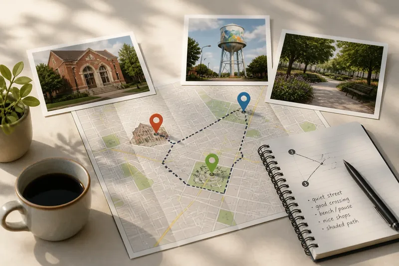
A new neighbourhood walk is easier to enjoy when you choose three visible landmarks before setting out. A library, a distinctive clock, and a small park can give an unfamiliar area a loose shape without turning the outing into a rigid march from one pin to another.
The point is not to see everything. It is to give yourself a few dependable bearings, then let the streets between them suggest a route. This works well for a free morning, a visit before meeting someone nearby, or a first walk after moving into the area.
Choose landmarks that help you read the neighbourhood
Pick places that are easy to recognize from the street and useful as orientation points. A church tower, a public library, a mural on a broad wall, a market entrance, or a planted square may all work. Favor visible features over places you can identify only by reading a sign at the door.
Give the landmarks different jobs. One can mark your starting edge, another can draw you toward the middle, and the third can make a natural turning point or endpoint. They do not need to form a straight line. A cluster of three nearby sites can reveal a compact area just as well as a long walk between distant sights.
Before leaving, check a current map such as Apple Maps, Google Maps, or OpenStreetMap. Use it to see where the landmarks sit and whether streets appear to connect them. Treat the map as a sketch rather than a promise: construction, access restrictions, and the feel of a street are easier to judge on the ground.
Plan the walk around one available morning
Start by deciding how much of your morning you can comfortably give the walk. Leave time for pauses, a coffee stop, or a change of direction. The route should fit the occasion, not force you to hurry to reach every landmark.
Use this simple sequence before you go:
- Choose a starting point. A transit stop, a public parking area, or a familiar corner can make the first turn easy to find.
- Mark three landmarks. Choose features that are visible, distinct from one another, and open to public view.
- Look for connecting streets. Trace a possible path between the landmarks, noting crossings, dead ends, hills, and roads that may be unpleasant to walk beside.
- Choose a loose order. Put the landmarks in an order that feels natural on foot, rather than following the order in which they appeared on the map.
- Keep one option open. Identify a nearby side street, public path, or place to pause if the planned connection feels dull, blocked, or confusing.
Say you have a free morning near a transit stop and choose a brick library, a painted water tower, and a pocket park as your landmarks. You sketch a route that passes the library first, follows a quieter street toward the tower, then loops back through the park. If the road beside the tower feels noisy, you can take the parallel street and still reach the same landmark; the route changes, but the walk keeps its shape.
Follow the links between landmarks, not just the pins
Once outside, notice what connects one landmark to the next. A street may run straight but feel exposed, while a slightly longer route passes shop windows, a shaded path, or a public bench. You are choosing a walk, not merely drawing the shortest line.
At each turn, look for a useful cue: a distinctive building, a street name, a visible tower, or the direction of a park entrance. On a phone, keep the map available without checking it at every corner. Frequent screen glances can make a walk feel like a navigation task and leave less attention for the block you are actually on.
Small changes in the street can tell you that the neighbourhood is shifting. You might notice a row of shops giving way to workshops, a busier road becoming residential, or a paved route opening into a green space. These observations are not a scorecard. They help you decide whether to continue along the planned connection or take another public street that seems more inviting.
Let the route change when the area offers a better path
A useful plan has room to bend. If a landmark is hidden behind trees, look for another way to orient yourself rather than circling the block in search of a perfect view. If a sidewalk ends or a crossing feels uncomfortable, turn back to a street with a clear pedestrian route. Never cross a barrier or enter a place that is not open to the public to preserve the original line.
When you revise the route, keep one landmark as your next destination and choose the safest, clearest public connection toward it. That prevents a small detour from becoming aimless wandering while leaving you free to explore. If the new path turns out to be less pleasant, use the map or a recognizable street name to return to a route you understand.
Weather, noise, and your own energy can also change the plan. A short loop may suit a rainy morning; a bench or cafe can become a sensible pause if you need one. If the area feels harder to read than expected, there is no need to force a full circuit. Reach one landmark, notice how it relates to the surrounding streets, and head back by a clear route.
What should you check before leaving?
How do I choose three landmarks?
Choose places or features that are distinct, visible from public streets, and separated enough to give the walk a sense of direction. A library, a mural, and a park entrance are often easier to tell apart than three similar storefronts.
Should I follow the shortest route?
Not necessarily. A parallel street may be calmer, more pleasant, or easier to cross, even if it adds a turn. Pick a route that suits your time and comfort rather than treating the map’s shortest line as a requirement.
What if one landmark is closed?
If you chose it for its exterior or position, you may still be able to use it as a bearing from the public street. If it is not visible or accessible, substitute a nearby feature you can identify without entering private property.
How can I keep from getting lost?
Keep track of street names and one recognizable landmark behind you, and save the route on your phone if that is convenient. If your bearings stop making sense, pause somewhere public and check the map before choosing the next turn.
Finish with a note that will help next time
At the last landmark, take a moment to remember what worked: perhaps the route was easy to follow, one crossing was awkward, or a side street offered a better connection than the map suggested. A brief note in your phone can preserve those useful details for another visit without turning your walk into a research project.
A new neighbourhood walk planned around three landmarks gives you structure without asking you to predict every turn. Choose clear bearings, make a route that fits the morning, and let what you see guide small adjustments. You will leave with a more usable sense of how the neighbourhood’s streets connect—and a starting point for exploring beyond the original loop.